


DALE TWP Voting District, Lyon County, Iowa
About
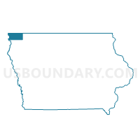
Outline

Summary
| Unique Area Identifier | 582727 |
| Name | DALE TWP Voting District |
| County | Lyon County |
| State | Iowa |
| Area (square miles) | 36.15 |
| Land Area (square miles) | 36.15 |
| Water Area (square miles) | 0.00 |
| % of Land Area | 100.00 |
| % of Water Area | 0.00 |
| Latitude of the Internal Point | 43.30168370 |
| Longtitude of the Internal Point | -95.92031080 |
Maps


Graphs
Select a template below for downloading or customizing gragh for DALE TWP Voting District, Lyon County, Iowa


Neighbors
Neighoring Voting District (by Name) Neighboring Voting District on the Map
- FLOYD TWP W/O SHELDON Voting District, O'Brien County, IA
- GILMAN TWP Voting District, Osceola County, IA
- GRANT TWP Voting District, Lyon County, IA
- GRANT TWP W/O SHELDON Voting District, Sioux County, IA
- LIBERAL TWP W/O GEORGE Voting District, Lyon County, IA
- SHERIDAN TWP Voting District, Sioux County, IA
- WEST HOLMAN TWP W/O SIBLEY Voting District, Osceola County, IA
- WHEELER TWP W/O GEORGE Voting District, Lyon County, IA
Top 10 Neighboring County Subdivision (by Population) Neighboring County Subdivision on the Map
- Floyd township, O'Brien County, IA (5,295)
- West Holman township, Osceola County, IA (2,106)
- Wheeler township, Lyon County, IA (1,157)
- Sheridan township, Sioux County, IA (1,137)
- Gilman township, Osceola County, IA (712)
- Grant township, Sioux County, IA (571)
- Liberal township, Lyon County, IA (385)
- Grant township, Lyon County, IA (262)
- Dale township, Lyon County, IA (223)
Top 10 Neighboring Unified School District (by Population) Neighboring Unified School District on the Map
- Sheldon Community School District, IA (7,323)
- Sibley-Ocheyedan Community School District, IA (4,733)
- George-Little Rock Community School District, IA (2,664)
Top 10 Neighboring State Legislative District Lower Chamber (by Population) Neighboring State Legislative District Lower Chamber on the Map
Top 10 Neighboring State Legislative District Upper Chamber (by Population) Neighboring State Legislative District Upper Chamber on the Map
Top 10 Neighboring 111th Congressional District (by Population) Neighboring 111th Congressional District on the Map
Top 10 Neighboring Census Tract (by Population) Neighboring Census Tract on the Map
- Census Tract 4902, O'Brien County, IA (3,807)
- Census Tract 701, Sioux County, IA (3,708)
- Census Tract 4601, Osceola County, IA (3,532)
- Census Tract 4602, Osceola County, IA (2,930)
- Census Tract 9501, Lyon County, IA (2,797)